Assessing the Ozark Plateau (continued) |
||||||||
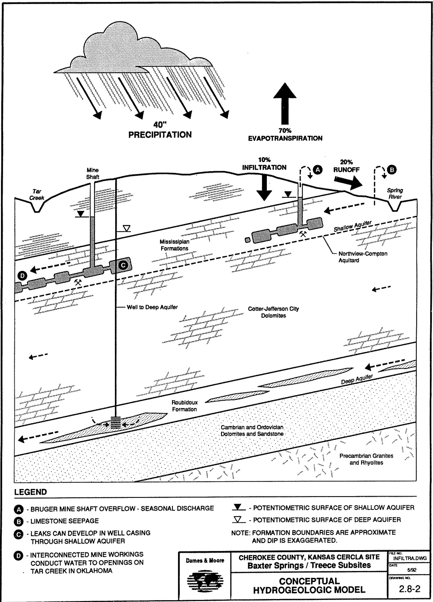
Hydrology Two major aquifers lie beneath the Ozark Plateau. The shallow aquifer, called the Boone aquifer, is comprised of Mississippian limestones, which also contain the lead-zinc deposits mined in the area. The rock underlying the Boone is impervious limestone, which restrains the aquifer and fundamentally prevents downward movement of the water. Water from the surface can sink into the ground and enter the more shallow aquifer through porous areas in the limestone or through mine workings, recharging the aquifer. During times of heavy rain, ground water in the Boone aquifer discharges into mine shafts and drill holes. Some discharge also runs from the Boone along the area’s streambeds directly to the Spring River. |
||||||||
|
||||||||
The Boone aquifer was formerly a source of drinking water by residents of Galena, however, the EPA concluded that metal pollution of the aquifer due to past mining in the area was serious enough to make the water unsafe for use. Effective in 1997, the deeper Roubidoux aquifer became the source for public, industrial, domestic and stock water. Recharge of this aquifer occurs via precipitation falling on the western side of the Ozark Dome in Missouri. The Roubidoux’s ground water flows out of Cherokee County to the west, then turns south toward Oklahoma. Downward leakage into the deeper aquifer from the Boone through fractures and well shafts is a possibility. The transmissivities of the Jefferson City and Cotter dolomites are more than an order of magnitude less than those of the Boone and Roubidoux formations, however, so the Jefferson City and Cotter formations act as a barrier to flow between the aquifers. To date downward leakage has not been identified as a significant source of recharge. Since the Roubidoux is used by residents in Missouri and Oklahoma as well, and groundwater demands are continuing to increase, contamination of the lower aquifer by the upper Springfield Plateau aquifer in Missouri is more of a concern for the future. To Top of Page |
||||||||
Surface water in the Ozark Plateau region primarily is a calcium
or calcium magnesium bicarbonate-type water. The southeast two-thirds of the Spring River basin is located in the Springfield Plateau Section
of the Ozark Plateaus Province. |
||||||||
|
||||||||
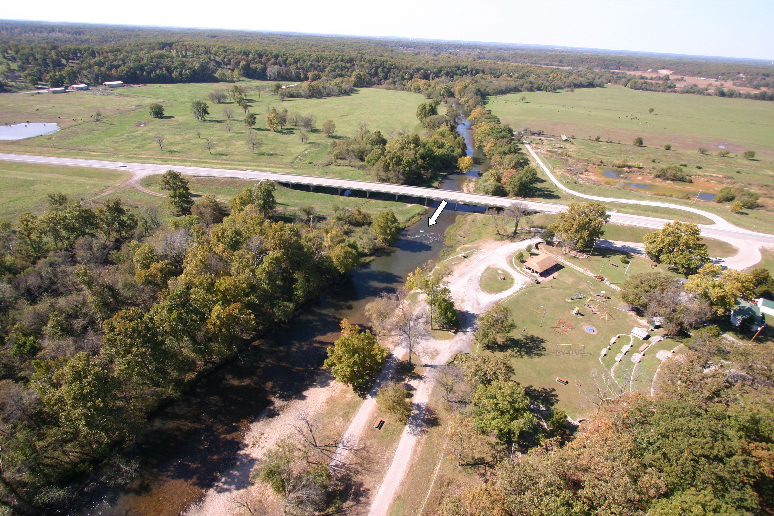
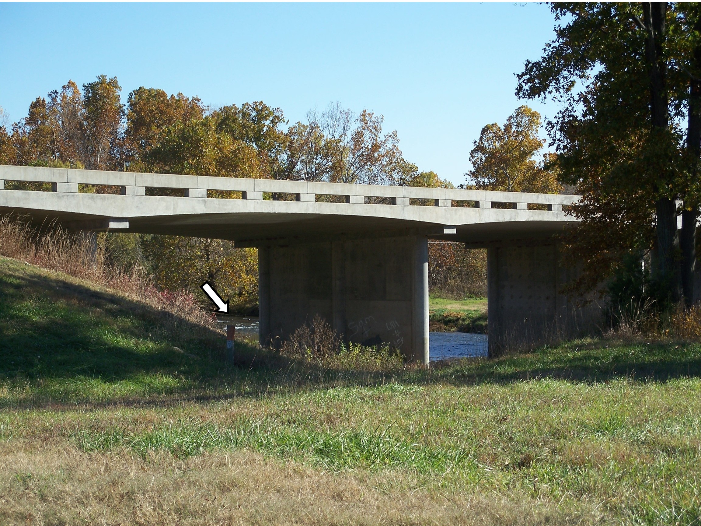
In the image to the right the bridge rests on sloping land. The aerial photograph provides much detail about land use, vegetation, the path of Shoal Creek bed and more. Areas of soil with little vegetation to the upper right are due to flooding from the creek as are the small pools near the access road across the highway. In both images, white areas in the creek are noticeable near the Shoal Creek bridge (see arrows). This is due to water running over exposed rocks. Rocky streambeds are typical of streams in the Ozark Plateau. The streams tend to be lined with limestone and chert with steeper inclines and more rapid flow than streams to the west of Spring River. The rocky streambed is noticeable at the bottom left third of the aerial image. The Spring River flows into Ozark Plateau about ten miles north of Galena. It is one of the state’s most important surface water resources, ranking fifth in annual average flow and third-highest in critical low flow (USGS WATSTORE database). This part of the basin is underlain by Mississippian age limestone. The basin is characterized by gently rolling uplands divided by streams. |
||||||||
|
||||||||
The river drains approximately 1,295 square kilometers (500 square miles) and flows through or near the Cherokee County Superfund subsites. The river exits the state into Oklahoma where it converges with the Neosho River to form Grand River. Some reaches of the river include low-lying natural lands that help reduce erosion and pollution from fertilizer runoff. To Top of Page |
||||||||
Empire Lake sits between the unincorporated villages of Riverton and Lowell, KS and covers approximately 840 surface acres. It is located within the Spring River Basin that drains about 6,475 square kilometers
of southwestern Missouri, southeastern Kansas, and northeastern Oklahoma (Seaber and others, 1987). Primary sources of flow into Empire Lake are the Spring River and Shoal Creek. Additional tributaries to
the Spring River and Empire Lake include Center Creek, Cow Creek, Shawnee Creek, Short Creek, and Turkey Creek. To note, Center, Short, and Turkey Creeks drain areas that have been affected by past
lead and zinc mining.
|
||||||||
|
||||||||
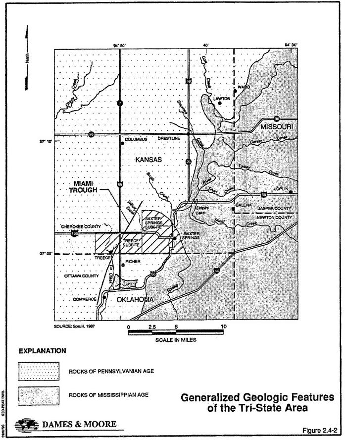
The image above (visit link for enlarged version) illustrates the location of the river, lake and streams as well as the Mississippian rock within the Ozark Plateau. It also highlights the extent of two of the EPA superfund
subsites impacted by mining.
|
||||||||
Empire Lake was created by a dam constructed in the early 1900s and is owned by Empire District Electric Company, which uses lake water as a coolant in its coal-fired power plant. Substantial amounts of sediment have accumulated behind the dam, the root cause of shallow water depths throughout most of the lake. The Kansas Department of Health and Environment (KDHE) reported in 2004 that the lake is weakened by siltation. To reach Empire Lake and the Dam, travel west in Riverton, KS on Hwy 66 and after ½ mile (0.8 kilometer) turn west on Hwy 69, then follow the road. The shape and geomorphic conditions of Empire Lake are emphasized by turning left after the dam onto the access road to the south as can be seen in stitched image accessed through the link below. |
||||||||
|
||||||||
To Top of Page
|
||||||||
| Home | Next-Assessing the Ozark Plateau (continued) |
|||||||